Laughton in East Sussex lies just off the main A22 Eastbourne to London road, on the
B2124 Hailsham to Ringmer road.
Stone implements have been found nearby, and the Romans built a villa
on land towards Ripe , probably for farming as the land is very fertile
lying as it does on a tributary of the river Ouse .
Until the Norman conquest in 1066 the area was owned by Earl Godwin, the
father of Harold II the last Saxon King of England. The ownership was passed
to Aquila family who founded Michelham Priory and who started to build
the church in 1229.
The Black Death appears to have effected the village as the church lies
just under a mile from the village centre.
In 1356 at the Battle of Poitiers a local knight Sir John Pelham together
with Sir Roger De La Warr captured Jean the King of France, because of
this Sir John was given the Kings belt buckle as a badge of honour.
This badge can be seen in many churches in the area showing the influence
and power of the Pelham family.
The Pelham family bought Laughton Place, an old fortified manor in 1466,
this was rebuilt in 1534 by William Pelham . The Pelhams built a new house
in Halland in the 1600's and moved there, but continued to be Lords of
the manor.
The area was once a major brick producer with four brickworks nearby. The
bricks were used to build Laughton Place , with production continuing
until the 1930's.
During the Second World War the village was hit by a doodlebug ( Flying Bomb )
and unusually for the villages in the area four people were killed.
Views
Laughton in East Sussex is on a slight rise in the flatlands between the South Downs and
the Ashdown Forest. It has views south to the Downs which can be spectacular
on a late summer afternoon.
Many of the houses in the village are old and attractive.
Services
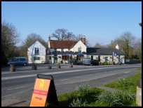
Laughton in East Sussex has a few local services as you would expect from a small village.
The nearest shopping centres are at Hailsham about 6 miles to the East
or Lewes about 6 miles West.
The nearest train service runs from Lewes with a regular service to London.
Map
Laughton is shown as the red symbol on the map.
Nearby Villages (click on symbol to see the village page)


 Laughton in East Sussex lies just off the main A22 Eastbourne to London road, on the
B2124
Laughton in East Sussex lies just off the main A22 Eastbourne to London road, on the
B2124 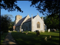 Laughton in East Sussex is on a slight rise in the flatlands between the South Downs and
the Ashdown Forest. It has views south to the Downs which can be spectacular
on a late summer afternoon.
Laughton in East Sussex is on a slight rise in the flatlands between the South Downs and
the Ashdown Forest. It has views south to the Downs which can be spectacular
on a late summer afternoon.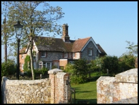 Laughton in East Sussex has a few local services as you would expect from a small village.


